![]()

Cataraqui Conservation Issues Watershed Conditions Statement | March 13, 2025


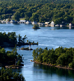

Cataraqui Conservation Issues Watershed Conditions Statement – Water Safety for Inland Lakes and Streams
Kingston – Cataraqui Conservation is advising residents regarding water safety during this period of increasing water levels and flows.
Weather Situation:
Temperatures have generally been fluctuating above and below the freezing mark for several days now. This will change March 13 or 14 when persistent above zero temperatures, forecast to exceed 10 degrees, are expected through Sunday, March 16, before dropping back down to seasonal temperatures March 17. There’s also 10 – 20 mm+ of rain forecast for March 15 and 16. Looking a bit further on, above normal temperatures are also forecast for March 19 and 20.
Conditions:
Spring freshet (snowmelt period) kicked off with the March 4 and 5 warm-up and rainfall.
Since then, the snowpack has been diminishing but at different rates, faster in southern areas and slower in northern areas. Considerable snowpack remains in many areas, especially in the north. The March 13 to 16 warm-up and rainfall could melt most of the remaining snowpack in many southern areas.
Streamflows are currently in the normal to above normal range for March. Most lake levels are in the normal range. The ground has been thawing but, due to the ongoing melt, has limited ability to infiltrate additional runoff. Water is already pooling in low-lying areas and roadside ditches. Runoff from snowmelt and rainfall will result in further increases to water levels and flows on inland lakes and streams in the coming days and weeks.
In general, normal springtime peak water levels and flows are expected in the coming days and weeks. Some areas could see higher than normal water levels and flows, especially if the higher rainfall amounts materialize. Streamflows are already higher than the unusually low flows observed last March.
Water Managers will continue to make discharge adjustments to manage, as much as possible, any excess flows coming through the system from snowmelt and rainfall. Target water levels generally trend upward through March to prepare for the summer recreation season.
Risks:
Cataraqui Conservation is urging caution around all dams (inflow and outflow channels) and fast-flowing watercourses. Respect the hazards in these areas by obeying all warning signs, and keep away from booms, buoys and barriers. Stay well back from the water’s edge above and below dams and hydroelectric stations. Creek banks and lake shorelines may be slippery, increasing the chance of falling in.
Ice conditions continue to deteriorate. Cataraqui Conservation does not measure ice thickness for advising the public about ice conditions for recreational activities. Ice conditions can vary considerably from one waterbody to the next and within a single waterbody. No ice is without some risk. Visit lifesaving.org for ice safety information.
Widespread flooding is NOT expected at this time. However, the usual springtime inundation of low-lying areas can be expected. Ice break-up is also possible, potentially leading to ice jams and localized flooding (e.g., at culverts and other restrictions). If you witness flooding and/or require assistance your first point of contact is the local municipality.
Staff will continue to monitor conditions and forecasts and will update statements as needed.
This Watershed Conditions Statement will remain in effect until (or updated before) Wednesday, March 26, 2025, at 11:59 PM.
For up-to-date flooding information, please visit our flood forecasting and information page at https://cataraquiconservation.ca/pages/flood
See below for watershed conditions terminology:
Normal: No flood conditions exist
Watershed Conditions Statement – Water Safety: High flows, unsafe banks, melting ice or other factors that could be dangerous for recreational users such as anglers, canoeists, hikers, children, pets, etc. Flooding is not expected.
Watershed Conditions Statement – Flood Outlook: Early notice of the potential for flooding based on weather forecasts calling for heavy rain, snow melt, high wind or other conditions that could lead to high runoff, cause ice jams, lakeshore flooding or erosion.
Flood Watch: Flooding is possible in specific watercourse or municipalities. Municipalities, emergency services and individual landowners in flood-prone areas should prepare.
Flood Warning: Flooding is imminent or already occurring in specific watercourses or municipalities. Municipalities and individuals should take action to deal with flood conditions. This may include road closures and evacuations.